Exploring the world for you
We're searching live sources and AI-curating the best destinations. This takes 10–20 seconds on first visit.
🌍Scanning destinations across 6 continents…
Public-transit-navigation captivates travelers who thrive on decoding a city's veins—subways, trams, buses pulsing with precision. Riders chase the thrill of seamless transfers, app-honed routes, and insider hacks that turn commutes into conquests. This passion rewards the map-obsessed with authentic glimpses into local rhythms, far from tourist shuttles.
Ranked by network integration, local approval, route density, English accessibility, and value from rider surveys and performance indexes.
Octopus card unlocks MTR's clockwork efficiency across 10 lines, ferries, and buses—riders rave about its seamlessness.[1] English signage and real-time apps make navigation intuit…
JR Lines, subways, and private rails form a hyper-punctual web; ICOCA/PASMO cards simplify vast interchanges.[2] Color-coded maps and announcements in English guide flawless hops. …
Metro's 20+ lines rocket at 430km total, with Alipay integration for ticketless entry.[1] Bilingual apps track crowds in real time. Spans Pudong to historic bunds effortlessly. **B…
EasyCard powers MRT's clean, frequent trains across urban sprawl; intuitive transfers at Taipei Main Station.[1] English prevalent, with low fares drawing daily explorers. Hill dis…
Oyster/Contactless taps into Tube, buses, DLR, and Overground; Night Tube extends 24/7 reach.[1] TfL app predicts delays across 272 stations. Zones 1-6 cover riverside to suburbs. …
Yikatong card navigates 27 metro lines at bargain speeds; English maps at key hubs.[1] Lines thread Forbidden City to Great Wall outskirts. App alerts handle peak surges. **Best Se…
MetroCard/OMNY spans 472 stations; 24/7 subway plus ferries link boroughs.[5] MTA app shows live arrivals. Iconic lines hit Times Square to Coney Island. **Best Season: Apr-Jun, Se…
Free Circulator buses complement Metro's color-coded lines; walk-up fares easy.[3] SmarTrip card covers Arlington to National Mall. High walkability boosts transfers. **Best Season…
Clipper card unites BART, Muni, and cable cars over 26 routes; bay ferries add flair.[3] Transit app integrates bikeshares. Hits Golden Gate to Mission District. **Best Season: Jun…
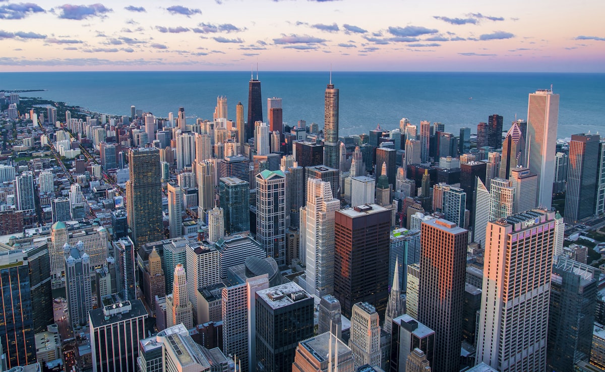
Ventra card powers L trains and buses across Loop to O'Hare; lakefront trails link.[5] Divvy bikes extend reach. 24/7 Red Line anchors grid. **Best Season: May-Oct**
Ruter app unifies electric buses, trams, metro, ferries on one ticket; Oslo Pass for unlimited.[1] Island hops via single top-up. Sustainable fleet sets green standard. **Best Seas…
Metro's 195 stations at 5 pesos; cable bus climbs hills.[2] English apps map centro to pyramids. Turistibus aids outskirts. **Best Season: Oct-May**
Nox card links buses and ferries; free silver Abras cross mangroves.[1] Apps guide to Louvre Abu Dhabi. Expanding gold line promises more. **Best Season: Oct-Apr**
SL Access card covers metro, buses, ferries across 14 islands.[2] Realtime.se app excels. Archipelago day trips seamless. **Best Season: May-Sep**
BVG app and ABC ticket zone the U/S-Bahn web; trams fill gaps.[2] Night networks run till dawn. Hits Brandenburg Gate to Tempelhof. **Best Season: May-Sep**
T-Casual 10-ride for metro, buses, trams; Hola BCN unlimited.[2] Covers Sagrada to beaches. Pickpocket-aware apps alert. **Best Season: Mar-May, Sep-Nov**
OPUS card unites metro, buses, REM trains; BIXI bikes integrate.[2] Snow-proof winter ops. Old Port to Mount Royal easy. **Best Season: May-Oct**
Rejsekort covers metro, buses, S-trains, harbor ferries.[2] Citymapper shines here. Bike-transit hybrid rules. **Best Season: May-Sep**
CharlieCard for T lines, buses, ferries; MBTA app tracks.[4] Historic Freedom Trail on Green Line. Harbor islands via commuter rail. **Best Season: May-Oct**
Navigo pass zones metro, RER, trams across city and Versailles.[2] RATP app multilingual. Night buses fill gaps. **Best Season: Apr-Oct**
T-Money card for subway, buses, taxis; English screens everywhere. KakaoMap dominates. Covers Gangnam to DMZ shuttles. **Best Season: Mar-May, Sep-Nov**
EZ-Link taps MRT, LRT, buses; SimplyGo app tracks spend. Spotless lines hit Marina Bay to Sentosa. **Best Season: Year-round**
Wiener Linien ticket for U-Bahn, trams, buses; weekly pass value. English app covers palaces to vineyards. **Best Season: Apr-Oct**
Multi-10 ticket for metro, buses, light rail; Abono monthly flexible. EMT app real-time. Hits Prado to Retiro. **Best Season: Mar-May, Sep-Nov**
Opal card unifies trains, ferries, buses, light rail; app caps daily spend. Harbour Bridge views from ferries. Covers CBD to Bondi. **Best Season: Sep-May**
Research city-specific apps like Citymapper or local equivalents weeks ahead to simulate routes. Time visits for off-peak hours to avoid rush crushes. Buy multi-day passes on arrival for seamless hopping.
Download offline maps and validate real-time via official apps to dodge delays. Observe local flow at major hubs for unspoken rules. Keep tickets digital to skip queues.
Practice transfer timing on shorter loops first. Learn basic phrases for ticket machines in non-English zones. Venture to underserved lines for authentic navigation wins.
Locals rank Hong Kong first for MTR efficiency, followed by Shanghai and Beijing for metro scale. Oslo earns praise for electric integration and Oslo Pass. Abu Dhabi and Taipei round out top five for …
Highlights New York, Edinburgh, Mexico City, Tokyo for eco-friendly, affordable transit. Notes London, Stockholm, Barcelona, Berlin, Montreal, Mumbai, Shanghai, Taipei, Chicago, Copenhagen as standout…
Washington DC tops with walkability and free options; San Francisco ties third with 26 routes. Details commute times, route counts, and scores. New York and others follow in national rankings.[3]
Washington DC leads, then San Francisco, Boston, Chicago, New York. Notes rising transit use, especially west and Texas. Pittsburgh highlighted for fast commutes.[4]
New York scores 9.6, San Francisco 9.3, Jersey City/Chicago 9.2 in transit access data. Covers US micro-areas for connectivity and frequency.[5]
Select a question below or type your own — AI will generate a detailed response.